


 다운로드 TOP50
 PC 카테고리
 자유게시판
자유게시판
SDVFR Next
 다운로드수 1,978
-
0 (0명)
| 분류 | 지도/내비게이션 |
|---|---|
| 버전 | 없음 |
| 연령 | 3세 이상 |
| 업데이트 | |
| 금주 다운수 | 0 |
| 누적 다운수 | 1,978 |
| 개발사 | SkyDreamSoft |
| 다운로드 | |
|
!소프트웨어 사용범위 위반 시
법적 책임을 질 수 있습니다. |
|


상세정보
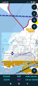
This application is designed for pilots of aircraft operating under visual flight rules VFR
SDVFR Next is the redesign of the SDVFR application Currently in beta testing thank you for your feedback on our forum
https//forumskydreamsoftfr or by mail at infoskydreamsoftfr
Coverage Artic France British Isles Eastern Europe Iberia Balkans Italia Scandinavia Central Europe
coming soon
Application in English or French
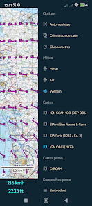
Home made Europe vector map
Day and night styles
Remove upper airspaces with a ceiling filter
Traditional SDOACI map still available
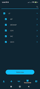
Free additional maps
Chargeable maps available see shop at https//skydreamsoftfr
Online maps plan terrain satellite hybrid
Use your maps in MBTiles format
Use your map layers KML GeoJSON SHP
Display several maps simultaneously
Change maps according to zoom
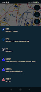
Manage your custom waypoints
Georeferenced VAC maps automatic zoom mode
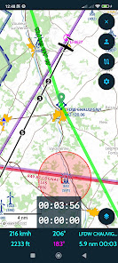
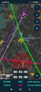
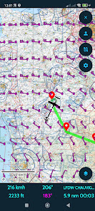
GPS tracking speed vector amp time bubbles
Be alerted in the event of loss of GPS or traffic stream GDL90
Estimation of wind aloft
Height estimation accurate terrain model
Magnetic declination
Map options autocenter orientation
Direct function including localities search
Live track
Replay tracks
Customisable black box
Export of tracks in KML and GPX formats
2D and 3D track display
Stopwatches
GEOID correction required on Android
VFR amp IFR Notams
Zones from SUPAIP
RTBA very low altitude network activations
Doubletap airspace details
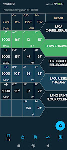
Flight profile
Navigation profile
Create your navigations in just a few clicks
Configurable flight log
Take into account climb/descent times
Drift and effective wind taken into account
Overlaps radio navigation
Help with choosing frequencies
Export and import of GPX KML PLN Flight Simulator and FPL Garmin navigations
METAR amp TAF amp SIGMET raw and decoded
Wintems 18 levels and 24hour forecasts
WINTEM and TEMSI weather maps from MtoFrance
Weather radar
Data sheets for your aircraft
Weight and balance screen
Fuel estimates
Narrow route weather terrain and notams on your route
Generation of complete flight dossier
French documentation VAC AIP ULM SUP AIP FFA ICARUS
Load your personal documents and associate them with custom waypoints
Library of VFR amp weather guides map supplements legends etc
Replace GPS with positioning from your flight simulator FS2020/4 FSX P3D XPlane FlightGear AeroFly
Use SafeSky or your traffic detection unit with GDL90
Synchronise navigations aircraft custom points and tracks between your terminals
Numerous customisation options
리뷰
- 소프트쉐어 신규 소프트웨어 추가 안내 2025.01.17
- 소프트쉐어 서비스 이용 가이드 업데이트 안내 2025.01.17
- 소프트쉐어 웹사이트 리뉴얼 안내 2025.01.17


